Machine Learning
GeoGuard: Satellite-Based Illegal Mining Detection System
Department of Computer Science and Engineering, Sri Shakthi Institute of Engineering and Technology, Coimbatore, Tamil Nadu, India
Published October 2026
Abstract
GeoGuard is a satellite-based illegal mining detection system designed to identify and monitor unauthorized mining activities in protected forests, no-mining zones, and environmentally sensitive areas. Illegal mining can cause deforestation, land degradation, and significant damage to natural resources, making continuous monitoring essential. The system uses satellite imagery, remote sensing, and image analysis techniques to detect changes in land surfaces over time. Sentinel-2 satellite images are analyzed to identify indicators such as vegetation loss, exposed soil, and excavation-like disturbances. The detected changes are compared with protected-zone and authorized mining boundaries to identify potentially illegal mining activities. The system provides location-based alerts and visualizes suspicious areas on an interactive map, including the affected region and detected changes. By reducing dependence on manual field inspections, GeoGuard enables faster and more efficient monitoring of large geographical areas. Overall, the proposed system supports environmental protection, improves mining surveillance, and assists authorities in taking timely action against unauthorized mining activities.
Keywords: illegal mining detection; NDVI; remote sensing; satellite imagery; Sentinel-2; geospatial analysis; vegetation monitoring; land cover change; environmental monitoring; GIS; image processing
1Introduction
Illegal mining is a major environmental problem that affects forests, agricultural land, water resources, biodiversity, and natural ecosystems. Unauthorized extraction of minerals can result in deforestation, soil degradation, habitat destruction, water pollution, and permanent changes to the landscape. Traditional methods of monitoring mining activities mainly depend on field inspections, manual surveys, and reports from local authorities. These methods are often time-consuming, expensive, and difficult to perform continuously over large and remote geographical regions. Therefore, an automated and scalable approach is required to monitor mining activities efficiently and identify potentially illegal operations at an early stage.
GeoGuard is a satellite-based illegal mining detection system developed to provide an intelligent and efficient solution for monitoring suspicious mining activities. The proposed system uses satellite imagery and geospatial technologies to observe changes in land surfaces over different periods. Instead of depending entirely on physical inspections, GeoGuard compares historical and recent satellite images to identify significant changes that may indicate mining-related disturbances. This approach enables authorities and environmental monitoring agencies to monitor large areas remotely and focus their attention on locations that require further investigation.
Satellite remote sensing plays an important role in environmental monitoring because it provides continuous observation of large geographical regions without requiring direct physical access. GeoGuard primarily utilizes multispectral satellite imagery such as Sentinel-2 data, which contains information from different spectral bands. These bands can be used to analyze vegetation, exposed soil, barren land, water bodies, and other surface characteristics. By processing this satellite information, the system can identify changes in land cover and detect regions where significant disturbances have occurred.
Vegetation loss is one of the important indicators considered by the proposed system because mining activities often require the removal of vegetation and topsoil. The Normalized Difference Vegetation Index (NDVI) can be calculated from satellite imagery to estimate vegetation conditions within a particular region. By comparing NDVI values from different time periods, GeoGuard can identify areas where vegetation has decreased significantly. In addition to vegetation loss, the system analyzes changes such as exposed soil, barren surfaces, and excavation-like patterns that may indicate mining-related land disturbance.
Change detection is performed by comparing satellite images acquired at different time periods. A single satellite image may not provide enough information to determine whether a particular disturbance is recent or has existed for a long period. Multi-temporal analysis allows GeoGuard to identify newly occurring changes and monitor the progression of existing disturbances. However, since natural events, agricultural activities, construction, and authorized mining can also produce changes in satellite images, detected disturbances are treated as potential alerts and require additional verification before being considered illegal mining.
Geospatial boundary verification is another important component of GeoGuard. The system compares detected land disturbances with geographical boundaries such as protected forests, no-mining zones, environmentally sensitive areas, and authorized mining regions. If a significant disturbance is detected inside a restricted or protected zone, it can be given higher priority for investigation. This combination of satellite-based change detection and geographical boundary analysis provides better context for identifying potentially unauthorized mining activities.
GeoGuard also provides location-based visualization of detected disturbances through an interactive map. When a suspicious region is identified, its geographical coordinates, affected area, and relevant change information can be displayed for the user. This allows authorities to quickly understand the location and extent of a potential mining activity. The system can also generate alerts or assign confidence scores based on factors such as vegetation loss, surface disturbance, and the location of the detected change. Such prioritization helps monitoring teams concentrate their resources on high-risk areas.
The proposed system reduces the dependency on continuous manual monitoring and improves the scalability of environmental surveillance. Monitoring large forests and remote mining regions through physical inspections requires considerable human resources, time, and financial investment. Satellite-based monitoring allows extensive areas to be analyzed periodically using remotely acquired data. The system can also maintain historical observations, enabling users to compare changes over multiple periods and identify regions experiencing repeated or continuous disturbances.
Artificial intelligence and machine learning techniques can further improve the detection and classification of mining-related land changes. Models can be trained using satellite images containing different land-cover and mining patterns to distinguish suspicious mining areas from normal environmental changes. GeoGuard can integrate image preprocessing, spectral analysis, NDVI calculation, image differencing, geospatial analysis, and machine learning to improve detection performance. However, automated results should be considered as indications rather than definitive evidence, since final confirmation of illegal mining may require field verification, authorized records, and appropriate legal procedures.
In conclusion, GeoGuard provides a scalable satellite-based approach for monitoring potential illegal mining activities using multi-temporal satellite imagery, remote sensing, vegetation analysis, change detection, and geospatial boundary verification. By identifying indicators such as vegetation loss, exposed soil, and excavation-like disturbances and presenting suspicious regions through map-based alerts, the system can support faster and more efficient environmental surveillance. It can assist government departments, forest authorities, and environmental agencies in identifying high-priority locations for field investigation while reducing the effort required for large-scale manual monitoring. Through the integration of satellite technology, GIS, image processing, and artificial intelligence, GeoGuard aims to contribute to the protection of natural resources, environmentally sensitive regions, and sustainable land management.
2Literature survey
Illegal mining is a major environmental concern that causes deforestation, soil degradation, habitat destruction, water pollution, and changes in land use. Conventional mining surveillance methods mainly depend on field inspections and manual reporting, which are difficult to perform continuously over large and remote areas. Recent research has therefore focused on using remote sensing, Geographic Information Systems (GIS), satellite imagery, and artificial intelligence to monitor land-cover changes and identify suspicious mining activities.
2.1Satellite-based environmental monitoring
Satellite remote sensing has become an important technology for monitoring environmental changes over large geographical regions. Satellites such as Sentinel-2 provide multispectral imagery that can be used to observe vegetation, soil, water bodies, and other land-cover characteristics. Studies have demonstrated that periodic satellite observations can effectively identify changes caused by human activities, including mining and deforestation. GeoGuard uses satellite imagery as the primary source of information for detecting and monitoring potential mining-related disturbances.
2.2Remote sensing for mining detection
Remote sensing techniques are widely used for identifying mining-related changes on the Earth's surface. Mining activities often create visible disturbances such as vegetation removal, exposed soil, excavation areas, and changes in land structure. Research has shown that spectral information from satellite images can help distinguish disturbed areas from surrounding natural landscapes. GeoGuard applies remote sensing techniques to analyze these surface characteristics and identify regions that require further investigation.
2.3NDVI-based vegetation analysis
The Normalized Difference Vegetation Index (NDVI) is one of the commonly used techniques for assessing vegetation health using satellite imagery. NDVI is calculated using near-infrared and red spectral bands and provides information about vegetation density and condition. Mining activities frequently result in vegetation removal, leading to a reduction in NDVI values. GeoGuard compares NDVI values from different time periods to identify significant vegetation loss that may indicate land disturbance.
2.4Multi-temporal change detection
Change detection involves comparing images captured at different periods to identify changes in geographical features. Research shows that multi-temporal satellite imagery is effective for monitoring land-use and land-cover changes caused by mining, construction, deforestation, and other human activities. By comparing historical and recent images, GeoGuard can identify newly disturbed areas and monitor the progression of existing disturbances. This provides a more reliable approach than analyzing a single satellite image.
2.5Land-cover and surface disturbance analysis
Mining activities can result in the conversion of vegetation-covered land into exposed soil, barren land, or excavation areas. Researchers have used satellite-based land-cover classification and spectral analysis to identify these changes. GeoGuard analyzes indicators such as vegetation loss, exposed soil, barren surfaces, and excavation-like patterns to detect potential mining-related disturbances. Combining multiple indicators can improve the reliability of the detection process.
2.6GIS and geospatial analysis
Geographic Information Systems (GIS) provide powerful tools for storing, analyzing, and visualizing geographically referenced information. Previous studies have used GIS to monitor mining areas, protected forests, land-use changes, and environmentally sensitive regions. GeoGuard integrates GIS-based analysis with satellite imagery to determine the geographical location of detected disturbances and compare them with protected and restricted zones.
2.7Protected zone and boundary verification
Identifying a land disturbance alone is not sufficient to determine whether mining is illegal because authorized mining and other activities can also produce similar changes. Research emphasizes the importance of comparing detected disturbances with administrative and regulatory boundaries. GeoGuard compares suspicious locations with protected forest boundaries, no-mining zones, environmentally sensitive areas, and authorized mining regions. This helps prioritize disturbances that occur within restricted areas.
2.8Artificial intelligence and machine learning
Artificial intelligence and machine learning techniques are increasingly being applied to satellite image classification and environmental monitoring. Machine learning models can learn patterns associated with different land-cover classes and identify suspicious changes automatically. Techniques such as Random Forest, Support Vector Machines, and neural networks have been explored for remote sensing classification. GeoGuard can integrate machine learning with image-processing and geospatial techniques to improve the classification of potential mining areas.
2.9Visualization and alert generation
Visualization is important for presenting complex satellite and geospatial information in an understandable form. Interactive maps can display detected areas, geographical coordinates, affected regions, and changes between different time periods. GeoGuard provides map-based visualization and location-based alerts for suspicious areas. This allows monitoring authorities to quickly identify high-priority locations and plan further field investigations.
2.10Limitations of existing approaches
Although satellite-based monitoring provides significant advantages, existing approaches may face challenges such as cloud cover, seasonal variations, differences in image quality, false detections, and difficulty distinguishing authorized activities from illegal activities. A single detection method may therefore not be sufficient for reliable illegal mining identification. GeoGuard addresses these limitations by combining multi-temporal satellite imagery, NDVI analysis, surface change detection, and geospatial boundary verification to provide a more comprehensive monitoring approach.
3Proposed methodology
3.1Enhanced satellite data processing
The proposed system collects and processes satellite imagery from sources such as Sentinel-2. Image preprocessing techniques are applied to improve the quality and consistency of satellite data before analysis. The system extracts relevant spectral information and prepares historical and recent images for comparison.
3.2Vegetation and land-cover analysis
GeoGuard analyzes vegetation and surface characteristics using satellite spectral information. NDVI is calculated to identify vegetation conditions, while other image characteristics are used to detect exposed soil, barren land, and surface disturbances. Significant changes between different periods are considered potential indicators of mining activity.
3.3Multi-temporal change detection
The system compares satellite images acquired at different time periods to identify newly occurring land disturbances. Historical and recent images are analyzed to determine whether vegetation loss, soil exposure, or excavation-like changes have occurred. This helps monitor the development of suspicious areas over time.
3.4Geospatial boundary verification
Detected disturbances are compared with geographical boundaries such as:
- Protected forest areas
- No-mining zones
- Environmentally sensitive areas
- Authorized mining regions
If a detected disturbance occurs within a restricted region, the system assigns higher priority to the location for further investigation.
3.5AI-based detection
Machine learning techniques can be integrated into the system to classify different land-cover patterns and improve the identification of potential mining areas. The model can analyze features such as vegetation change, surface characteristics, and spatial information to generate a confidence score for suspicious regions.
3.6Location-based alert generation
When significant changes are detected, GeoGuard generates an alert containing relevant information such as:
- Geographical coordinates
- Detected change area
- Type of disturbance
- Change intensity
- Confidence or risk score
This helps authorities identify areas requiring immediate attention.
3.7Interactive map visualization
The system presents detected mining-related disturbances through an interactive map. Users can view satellite imagery, affected regions, coordinates, protected boundaries, and detected changes. Visual comparison between historical and recent images helps users understand the nature and extent of the disturbance.
3.8Automated monitoring
GeoGuard is designed to support periodic monitoring of selected geographical regions. New satellite images can be analyzed as they become available, allowing the system to identify newly emerging disturbances without requiring continuous manual inspection.
3.9Scalable and modular architecture
The proposed system follows a modular architecture that allows additional satellite datasets, machine learning models, geographical boundaries, and analysis techniques to be integrated in the future. This makes the system suitable for monitoring multiple regions and expanding to large-scale environmental surveillance.
3.10Human verification and decision support
The system treats detected areas as potential illegal mining alerts rather than final proof of illegal activity. Authorities can use the generated location, satellite evidence, and change information to prioritize field inspections and verify the activity using official records. This combination of automated detection and human verification improves the reliability of the overall monitoring process.
4System implementation
The implementation of the GeoGuard: Satellite-Based Illegal Mining Detection System focuses on developing an intelligent and scalable platform for monitoring potential illegal mining activities using satellite imagery, remote sensing, GIS, and image analysis techniques. The system processes historical and recent satellite images to identify changes in land cover, vegetation loss, exposed soil, and excavation-like disturbances. These detected changes are analyzed and compared with protected and restricted geographical boundaries to identify areas that require further investigation.
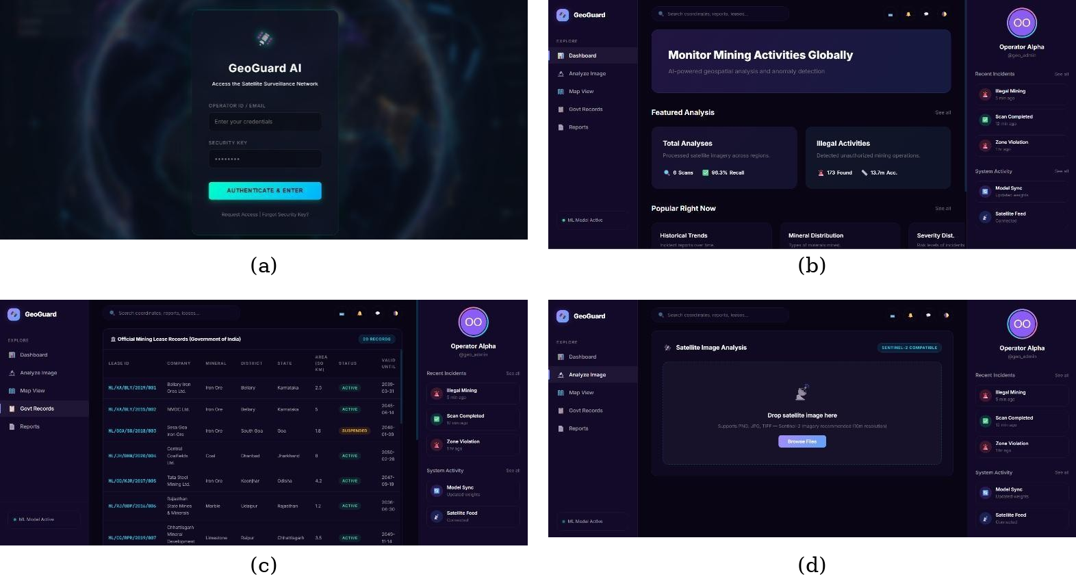
The frontend is developed as a web-based interface that provides users with an interactive dashboard for monitoring detected mining-related changes. The interface allows users to select monitoring regions, view satellite images, compare historical and recent imagery, and visualize detected suspicious areas on an interactive map. Important information such as geographical coordinates, affected area, change intensity, and detection status is presented in a simple and user-friendly manner.
The backend manages satellite data processing, image analysis, NDVI calculation, change detection, geospatial boundary verification, and alert generation. Python-based libraries and geospatial processing tools are used to process satellite imagery and extract relevant features. The system compares multi-temporal satellite images to identify significant changes and generates potential illegal mining alerts when suspicious disturbances are detected.
The implementation combines multiple analysis techniques instead of depending on a single indicator. Vegetation loss is analyzed using NDVI, while exposed soil, barren land, and excavation-like patterns are identified through satellite image comparison. The detected regions are then cross-checked with protected forest areas, no-mining zones, and authorized mining boundaries. This combined approach improves the reliability of the detection process and helps reduce unnecessary alerts.
Interactive visualization tools are used to display satellite imagery, detected changes, geographical boundaries, and alert locations. The system provides map-based visualization so that users can easily understand the location and extent of potential mining activities. The implementation is designed to support efficient environmental monitoring and assist authorities in prioritizing areas for further field-level verification.
4.1Hardware requirements
The hardware requirements for the GeoGuard system are moderate because satellite image processing and analysis can be performed using a server or cloud-based environment.
- Processor: Intel i5 or higher
- RAM: Minimum 8 GB; 16 GB recommended for large satellite datasets
- Storage: Minimum 256 GB SSD
- Graphics: Integrated graphics are sufficient for basic processing; dedicated GPU can be used for advanced machine learning
- Internet: Stable high-speed internet connection for accessing satellite and geospatial data
Key considerations:
- Efficient processing of satellite imagery
- Smooth execution of image-processing operations
- Storage of historical and recent satellite images
- Support for geospatial and machine learning operations
- Reliable internet connectivity for satellite data access
Users can access the system through a standard laptop or desktop computer because the major image-processing and analytical operations can be performed on the backend or cloud environment.
4.2Software requirements
The system uses various software tools and frameworks for satellite data processing, geospatial analysis, visualization, and machine learning.
- Programming Language: Python 3.10+
- Frontend: HTML, CSS, JavaScript
- Backend: FastAPI / Flask
- Satellite Data: Sentinel-2 imagery
- Image Processing: OpenCV, Rasterio
- Geospatial Processing: GeoPandas, GDAL
- Numerical Processing: NumPy, Pandas
- Machine Learning: Scikit-learn
- Visualization: Folium, Plotly, Matplotlib
- GIS: QGIS
- Development Tool: Visual Studio Code, Jupyter Notebook
- Version Control: Git and GitHub
- Database: PostgreSQL/PostGIS or MongoDB
These tools provide the required environment for collecting, processing, analyzing, visualizing, and storing satellite and geospatial information.
4.3Software description
The GeoGuard system is a web-based satellite monitoring platform designed to identify potential illegal mining activities through automated analysis of satellite imagery. The main functionalities include:
- Satellite image acquisition and processing
- Multi-temporal image comparison
- NDVI-based vegetation analysis
- Land-cover and surface disturbance detection
- Geospatial boundary verification
- Potential illegal mining detection
- Location-based alert generation
- Interactive map visualization
- Historical change monitoring
The backend processes satellite images and performs preprocessing, NDVI calculation, image differencing, and change detection. Suspicious regions are identified based on significant environmental and surface changes. These regions are then compared with protected and restricted geographical boundaries to determine their priority for investigation.
The system architecture is modular, allowing additional satellite datasets, machine learning models, GIS layers, and detection techniques to be integrated in the future. The dashboard provides a simplified representation of complex satellite and geospatial information through maps, images, charts, and alerts. This enables environmental authorities and monitoring teams to identify suspicious areas efficiently and make better-informed decisions.
The system is designed as a decision-support tool, meaning that detected regions represent potential mining activity and should be verified through field inspection and authorized records before taking legal action. This combination of automated satellite monitoring and human verification provides a practical approach for large-scale environmental surveillance and protection of natural resources.
5Advantages
- Improved environmental monitoring: Uses satellite imagery and remote sensing techniques to monitor large geographical areas and identify potential illegal mining activities efficiently.
- Early detection: Identifies land disturbances such as vegetation loss, exposed soil, and excavation-like changes at an early stage.
- Multi-temporal analysis: Compares historical and recent satellite images to detect changes in land cover and monitor mining-related activities over time.
- NDVI-based detection: Uses NDVI analysis to identify vegetation loss and changes in vegetation conditions that may indicate mining activity.
- Protected zone verification: Compares detected disturbances with protected forests, no-mining zones, and environmentally sensitive areas to identify high-risk locations.
- Reduced manual monitoring: Reduces the need for continuous physical inspections by automatically analyzing satellite images and highlighting suspicious regions.
- Interactive map visualization: Displays detected areas, geographical coordinates, boundaries, and satellite imagery through an interactive map for easy interpretation.
- Location-based alerts: Generates alerts for suspicious regions and provides information such as location, affected area, and detection intensity.
- Large-scale monitoring: Can monitor large and remote geographical regions that are difficult to inspect manually, making the system suitable for extensive environmental surveillance.
- Historical change tracking: Maintains and compares previous observations to track the progression of land disturbances and identify repeated mining-related changes.
- Decision support: Provides authorities with satellite-based evidence and prioritized locations that can assist in planning field inspections and investigations.
- Scalable and flexible: Can be extended with additional satellite datasets, machine learning models, GIS layers, and monitoring regions according to future requirements.
6Results and analysis
The GeoGuard: Satellite-Based Illegal Mining Detection System successfully provides a platform for monitoring potential illegal mining activities using satellite imagery, remote sensing, image processing, and geospatial analysis. The system processes historical and recent satellite images to identify changes in land cover and surface conditions. The detected changes are converted into meaningful outputs such as vegetation-loss regions, disturbed areas, potential mining locations, and map-based alerts. This enables users to monitor large geographical regions more efficiently than conventional manual inspection methods.
The system processes Sentinel-2 satellite imagery and performs preprocessing to prepare the images for analysis. Historical and recent images are compared to identify significant changes in the monitored region. Areas experiencing vegetation loss, exposed soil, barren land, and excavation-like disturbances can be highlighted for further investigation. The system provides a visual representation of these changes, allowing users to understand the location and extent of land disturbances. The NDVI-based analysis further helps identify areas where vegetation has significantly decreased, providing an important indicator of possible mining-related activity.
One of the key outcomes of the system is multi-temporal change detection, which compares satellite images captured during different periods to identify newly disturbed regions. The system also performs geospatial boundary verification by comparing detected disturbances with protected forests, no-mining zones, environmentally sensitive areas, and authorized mining boundaries. When significant changes are detected within restricted regions, those locations are given higher priority for investigation. This combined analysis improves the reliability of potential illegal mining detection.
The interactive dashboard provides clear visualization of detected regions through satellite images, maps, geographical coordinates, affected areas, and change indicators. The system can also generate location-based alerts containing information such as the detected disturbance, affected area, location, and confidence or risk level. These features help monitoring teams identify high-priority areas without manually inspecting the entire region. Historical observations can also be maintained to track whether a suspicious disturbance is increasing, decreasing, or remaining unchanged over time.
Overall, the results demonstrate that GeoGuard can serve as an effective decision-support system for satellite-based environmental monitoring and potential illegal mining detection. By combining satellite imagery, NDVI analysis, multi-temporal change detection, GIS, and image-processing techniques, the system reduces manual monitoring efforts and supports large-scale surveillance. It helps authorities identify suspicious locations for further field investigation and promotes better protection of forests and environmentally sensitive areas. However, satellite-based results should be considered potential indicators, and final confirmation of illegal mining should be performed through field verification and authorized records.
7Conclusion
The GeoGuard: Satellite-Based Illegal Mining Detection System successfully demonstrates how satellite imagery, remote sensing, GIS, image processing, and intelligent analysis can be combined to support the detection and monitoring of potential illegal mining activities. The system provides a centralized platform for analyzing geographical changes and identifying suspicious land disturbances across large and remote areas.
By integrating Sentinel-2 satellite imagery, NDVI analysis, and multi-temporal change detection, the system can identify important indicators such as vegetation loss, exposed soil, barren land, and excavation-like disturbances. The comparison of historical and recent satellite images helps monitor changes over time and provides useful information about the location and extent of potentially affected areas.
The integration of geospatial boundary verification further improves the effectiveness of the system by comparing detected disturbances with protected forests, no-mining zones, environmentally sensitive areas, and authorized mining regions. Interactive maps and location-based alerts help users visualize suspicious regions and prioritize areas that require further investigation.
GeoGuard reduces the dependency on continuous manual monitoring and provides a scalable approach for environmental surveillance. It can assist government departments, forest authorities, and environmental monitoring agencies in identifying high-priority locations for field verification. The system also provides a foundation for incorporating advanced machine learning models and additional satellite datasets in the future to improve detection accuracy.
Overall, GeoGuard offers a practical and efficient approach to satellite-based illegal mining monitoring. By combining remote sensing, satellite image analysis, NDVI, GIS, and change detection, the system supports faster identification of environmental disturbances and contributes to the protection of forests, natural resources, and environmentally sensitive regions. The detected results should be treated as potential indicators and verified through field inspections and authorized records before taking final action.
8Future work
The GeoGuard: Satellite-Based Illegal Mining Detection System can be further enhanced by integrating advanced technologies and expanding its monitoring capabilities:
- AI Model Improvement: Incorporating advanced deep learning and computer vision models to improve the accuracy of mining-area classification and reduce false detections.
- Real-Time Satellite Monitoring: Integrating frequently updated satellite imagery to provide faster detection of newly emerging mining activities.
- Advanced Change Detection: Implementing advanced image-processing and change-detection techniques to identify smaller and more complex mining disturbances.
- Multi-Satellite Integration: Combining Sentinel-2 with other satellite data sources such as Sentinel-1 and higher-resolution imagery for improved detection under different environmental conditions.
- Cloud Integration: Deploying the system on cloud platforms to process large volumes of satellite imagery and support monitoring of multiple geographical regions.
- Automated Alert System: Developing automated notifications through email, SMS, or dashboard alerts when suspicious mining activities are detected.
- Advanced GIS Visualization: Adding interactive 3D maps, historical timelines, area measurements, and detailed satellite-image comparisons for better analysis.
- Predictive Monitoring: Using historical mining patterns and machine learning to predict areas that may be at higher risk of future illegal mining activities.
- Mobile Application Support: Developing Android and iOS applications to allow authorities and field officers to access alerts and geographical information remotely.
- Integration with Government Data: Connecting the system with authorized mining permits, land records, forest boundaries, and environmental databases for improved verification.
In the future, GeoGuard can evolve into a fully automated and intelligent environmental monitoring platform capable of continuously analyzing satellite data, detecting land-cover changes, generating alerts, and predicting high-risk mining regions. Such improvements can make the system a valuable tool for government authorities, forest departments, and environmental agencies in protecting natural resources and controlling unauthorized mining activities.
References
- [1]Sonter W, Barrett DJ, Soares-Filho BS, Ferreira LJPR. Mining drives extensive deforestation in the Brazilian Amazon. Nature Communications. 2017;8.
- [2]Assis EDVD, Oliveira ACS, Souza MAF. Remote sensing and GIS techniques for monitoring environmental impacts of mining activities. Remote Sensing Applications: Society and Environment. 2021.
- [3]Maus V, Giljum S, et al. An update on global mining land use. Scientific Data. 2022;9.
- [4]Alqurashi AT, Kumar L. Land use and land cover change detection using remote sensing and GIS techniques. Advances in Remote Sensing. 2013.
- [5]Gorelick N, Hancher M, Dixon M, Ilyushchenko S, Thau D, Moore R. Google Earth Engine: Planetary-scale geospatial analysis for everyone. Remote Sensing of Environment. 2017;202:18–27.
- [6]Drusch M, et al. Sentinel-2: ESA's optical high-resolution mission for GMES operational services. Remote Sensing of Environment. 2012;120:25–36.
- [7]Claverie M, et al. The harmonized Landsat and Sentinel-2 surface reflectance data set. Remote Sensing of Environment. 2018;219:145–161.
- [8]Benediktsson JA, Chanussot J, Fauvel M. Multiple classifiers for hyperspectral data analysis. IEEE Transactions on Geoscience and Remote Sensing. 2007;45(12):3807–3819.
- [9]Blaschke T. Object based image analysis for remote sensing. ISPRS Journal of Photogrammetry and Remote Sensing. 2010;65(1):2–16.
- [10]Singh A. Digital change detection techniques using remotely-sensed data. International Journal of Remote Sensing. 1989;10(6):989–1003.
- [11]Jensen JR. Remote sensing of the environment: an earth resource perspective. 2nd ed. Pearson Education; 2007.
- [12]Lillesand TM, Kiefer RW, Chipman JW. Remote sensing and image interpretation. 7th ed. Wiley; 2015.
- [13]Tucker CJ. Red and photographic infrared linear combinations for monitoring vegetation. Remote Sensing of Environment. 1979;8(2):127–150.
- [14]Huete A, Didan K, Miura T, Rodriguez EP, Gao X, Ferreira LG. Overview of the radiometric and biophysical performance of the MODIS vegetation indices. Remote Sensing of Environment. 2002;83(1):195–213.
- [15]Chen CF, et al. Monitoring land cover and land use changes using multi-temporal satellite imagery. Remote Sensing. 2019.
- [16]Sathyabama P, Karthik DB. A multi-modal AI framework for real-time illegal sand mining detection and prevention using SAR satellite imagery and IoT-enabled seismic sensors in India. Shanlax International Journal of Arts, Science and Humanities. 2026;13.
- [17]Mensah JJ, et al. A Sentinel-2 based multispectral convolutional neural network for detecting artisanal small-scale mining in Ghana. Remote Sensing of Environment. 2021.
- [18]Kushwaha SPS. Impact of mining activities on land use land cover in the Jharia Coalfield, India. Elsevier. 2015.
- [19]Singh SK, Singh RK. Remote sensing based monitoring of mining-induced land cover changes. International Journal of Remote Sensing. 2018.
- [20]Jain SK, Singh AK, Sharma AK. Remote sensing and GIS based assessment of environmental impacts of mining. Environmental Monitoring and Assessment. 2019.
- [21]Roy P, Roy S, Chakraborty A. Land use and land cover change analysis using satellite imagery and GIS. Journal of Earth System Science. 2015.
- [22]Mishra SK, Kumar R. Application of GIS and remote sensing for monitoring mining areas. International Journal of Geoinformatics. 2018.
- [23]Wu J, et al. Remote sensing monitoring of mining areas and ecological environmental changes. Remote Sensing. 2020.
- [24]Pandey R, Nathawat PK. Land use and land cover mapping through digital image processing and GIS. International Journal of Remote Sensing. 2011.
- [25]Srivastava SK. Remote sensing based change detection for environmental monitoring. In: IEEE International Geoscience and Remote Sensing Symposium. 2017.
- [26]Chen JM, Pavlic G, Brown LL, Cihlar J, Leblanc SG, White JH. Derivation and validation of Canada-wide coarse-resolution satellite-based land cover. Remote Sensing of Environment. 2004.
- [27]Bruzzone L, Fernández Prieto D. An adaptive parcel-based technique for unsupervised change detection. International Journal of Remote Sensing. 2000;21(4):817–822.
- [28]Nielsen A. The regularized iteratively reweighted MAD method for change detection in multi- and hyperspectral data. IEEE Transactions on Image Processing. 2007;16(2):463–478.
- [29]Camps-Valls G, Gómez-Chova L, Muñoz-Marí J, Rojo-Álvarez JL, Martínez-Ramón M. Kernel-based framework for multi-temporal remote sensing image classification and change detection. IEEE Transactions on Geoscience and Remote Sensing. 2008.
- [30]Ghosh S, Roy PD, Das AK. Satellite image classification and land cover change detection using machine learning. IEEE Access. 2020.
- [31]Ma A, Zhang Y, Li X. Deep learning for remote sensing image classification and change detection. IEEE Geoscience and Remote Sensing Magazine. 2019.
- [32]Skidmore AK, et al. Environmental monitoring using remote sensing and geospatial technologies. Remote Sensing of Environment. 2021.
- [33]Goodchild MF. Geographic information systems and science: The foundations of geospatial analysis. International Journal of Geographical Information Science. 2018.
- [34]Ministry of Mines, Government of India. Mining Surveillance System (MSS): Satellite-based monitoring system for detection of illegal mining activities. Government of India.
- [35]Tatem AJ, Noor AM, von Hagen C, Di Gregorio A, Hay SI. High resolution population maps in remote sensing and GIS applications. Remote Sensing of Environment. 2007.