Environmental Science
Spatial Distribution of Reported Malaria, Measles and Cholera Cases Across Six Local Government Areas in Kogi State, Nigeria
Department of Geography, Faculty of Environmental Sciences, Nasarawa State University, Keffi, Nasarawa State, Nigeria
Published October 2026
Abstract
This study mapped the spatial distribution of reported malaria, measles and cholera cases across six Local Government Areas in Kogi State, Nigeria, namely Adavi, Okene, Bassa, Dekina, Kabba/Bu and Lokoja, using twenty-one years, 2005 to 2025, of disease surveillance records obtained from the Federal Ministry of Health, the Kogi State Ministry of Health and the Nigeria Centre for Disease Control and Prevention. Disease records were integrated with the administrative boundaries of the six Local Government Areas within a Geographic Information System to visualise the spatial pattern of reported cases of each disease. The results show that cholera incidence was densely concentrated in the riverine Local Government Areas of Lokoja, Bassa and Kabba/Bu, all situated along the Niger and Benue rivers, where seasonal flooding, poor drainage and contaminated water sources facilitate the spread of Vibrio cholerae. Malaria incidence showed widespread but pronounced clustering in Lokoja, Adavi, Kabba/Bu and Dekina, consistent with the high rainfall, humidity and vegetation density of these areas, which support Anopheles mosquito breeding and accelerated parasite development. Measles incidence was more evenly spread across the state but was notably clustered in Kabba/Bu, Bassa and Adavi, a pattern associated with routine immunization coverage, population density and seasonal indoor crowding. Lokoja and Bassa emerged as Local Government Areas of compounded vulnerability, where all three diseases overlapped, reflecting the intersection of climatic, hydrological and infrastructural stressors. The study concludes that the spatial distribution of malaria, measles and cholera in Kogi State is shaped by the interaction of geography, climate and infrastructure, and recommends disease-specific, spatially targeted interventions, including cholera-safe water infrastructure in riverine areas, malaria vector control in high-vegetation zones, and year-round measles immunization drives in high-density Local Government Areas.
Keywords: spatial distribution; malaria; measles; cholera; geographic information system; Kogi State
1Introduction
Weather patterns across the world have undergone significant change in recent decades, with more intense rainfall and more extreme temperatures becoming increasingly common, carrying environmental and public health implications for water quality, vector habitats, and the timing and distribution of infectious diseases. Climate variability and change are already increasing morbidity and mortality by altering the distribution and seasonality of vector borne diseases such as malaria and by intensifying the risk of water borne outbreaks such as cholera, while extreme temperatures and widespread flooding further overwhelm health systems and exacerbate existing vulnerabilities (Trisos et al., 2022).
Nigeria continues to contribute significantly to the global malaria burden, and national public health surveillance reports show that extreme rainfall and flooding are linked to recurrent spikes in the incidence of cholera and other water related illnesses (Nigeria Centre for Disease Control, 2022). Kogi State, situated at the confluence of the Niger and Benue rivers and characterised by low lying, flood prone terrain, has experienced recurrent extreme flooding alongside documented disease outbreaks across several Local Government Areas, making it particularly susceptible to the climate-health risks identified in both national and global research (Oyedele et al., 2022).
While the general relationship between weather elements and disease incidence has received growing research attention in Nigeria, the spatial pattern of malaria, measles and cholera cases across Kogi State's Local Government Areas has not been systematically mapped. Understanding where these diseases concentrate, and whether their spatial patterns overlap, is essential for targeting disease surveillance, resource allocation and public health interventions. This study therefore maps the spatial distribution of reported malaria, measles and cholera cases across six selected Local Government Areas in Kogi State, providing a geographic basis for disease-specific, spatially targeted public health planning.
2Study area
Kogi State is located in north-central Nigeria and is popularly known as the Confluence State because of the confluence of the rivers Niger and Benue at its capital, Lokoja. The State lies between longitudes 5°23′E and 7°48′E, and latitudes 6°30′N and 8°48′N, within the tropical Guinean forest-savanna mosaic ecoregion. It has a landmass of 29,833 km2 and shares boundaries with ten other states, a feature unique to Kogi among Nigeria's thirty-six states (Abiodun, 1985). Kogi State comprises twenty-one Local Government Areas, of which six were purposively selected for this study, two from each of the three senatorial districts: Adavi and Okene from Kogi Central, Bassa and Dekina from Kogi East, and Kabba/Bu and Lokoja from Kogi West. These Local Government Areas were selected because of their proximity to major rivers, their history of recurrent flooding, and their consequent vulnerability to climate-related health risks. The study area is shown in Figure 1.
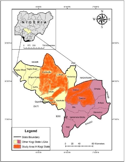
Kogi State experiences a tropical climate characterised by high temperatures, humidity and significant rainfall, with average temperatures ranging between 23.2 and 39.5 °C and relative humidity between 30 and 70%. The State has two main seasons, a wet season from April to October, during which the bulk of the annual rainfall of 1,300 to 1,800 mm is received, and a dry season dominated by the dusty, cold Harmattan winds. Kogi State was among the states worst affected by the 2022 floods in Nigeria, with residents in vulnerable communities coping with the catastrophic effects of flooding in various ways, including through disease transmission (Aladejana and Ebijuoworih, 2024).
The State's relief is largely mountainous, consisting of rocky, undulating highlands averaging 1,400 m above sea level in the uplands, descending to around 300 m along the Niger-Benue confluence. It is drained by the rivers Niger and Benue, which meet at the confluence in Lokoja, together with their tributaries, forming four major drainage basins. The flood plains of the two rivers are wide, reaching about 1,600 m in Lokoja, and while these water bodies support agriculture, fishing and domestic water use, they also present recurring challenges of flooding, erosion and water contamination that encourage the breeding of disease-causing pathogens. Vegetation is divided between rainforest in the east and woodland savanna and grassland to the west, and agriculture, crude oil extraction and solid mineral exploitation form the backbone of the State's economy.
3Methodology
3.1Data sources
Monthly records of reported malaria, measles and cholera cases covering twenty-one years, 2005 to 2025, were obtained for the six selected Local Government Areas from the Federal Ministry of Health, the Kogi State Ministry of Health and the Nigeria Centre for Disease Control and Prevention. All records were reviewed for completeness and consistency prior to spatial analysis.
3.2Spatial mapping procedure
A map showing the spatial distribution of reported malaria, measles and cholera cases was generated using a Geographic Information System. The Geographic Information System procedure integrated the disease records with the administrative boundaries of the six selected Local Government Areas to visualise the spatial pattern of reported cases of each disease, with cholera, malaria and measles cases distinguished by separate point symbols overlaid on the Local Government Area boundaries, road network and river system of the study area.
4Results
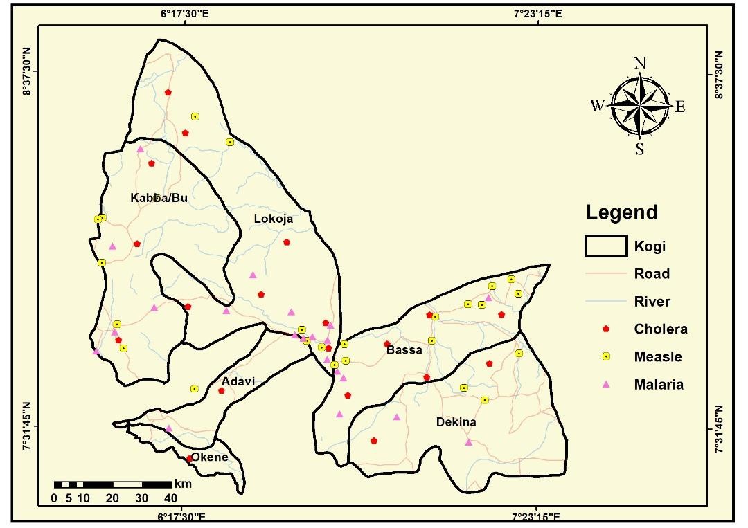
Figure 2 presents a comprehensive spatial representation of the incidence of malaria, measles and cholera cases across the six Local Government Areas of Kabba/Bu, Lokoja, Adavi, Okene, Bassa and Dekina in Kogi State. It illustrates how geographical features, population distribution and environmental conditions interact to influence where each disease concentrates, and shows that each disease forms its own distinct pattern of spatial clustering, shaped by climate, local ecology and the quality of infrastructure.
4.1Spatial pattern of cholera incidence
Cholera incidence was densely concentrated in the riverine Local Government Areas of Lokoja, Bassa and Kabba/Bu, all situated along the Niger and Benue rivers. These zones are prone to seasonal flooding, poor drainage and water contamination, particularly during the rainy season, conditions that facilitate the rapid spread of Vibrio cholerae through unsafe drinking water and inadequate sanitation (Levy et al., 2016; World Health Organization, 2023). The proximity of these Local Government Areas to transportation routes and river systems additionally amplifies exposure through increased population mobility and environmental vulnerability. The concentration by LGA is summarised in Table 1.
| Local Government Area | Cholera Concentration | Key Contributing Factor |
|---|---|---|
| Lokoja | High | Confluence location, flooding, water contamination |
| Bassa | High | Riverine location, poor drainage |
| Kabba/Bu | High | Proximity to river system, seasonal flooding |
| Dekina | Moderate | Partial riverine exposure |
| Adavi | Low | Limited direct river proximity |
| Okene | Low | Limited direct river proximity |
Source: authors’ analysis of disease surveillance records.
4.2Spatial pattern of malaria incidence
Malaria incidence showed widespread but pronounced clustering in Lokoja, Adavi, Kabba/Bu and Dekina. These areas exhibit high rainfall, humidity and vegetation density, conditions that support Anopheles mosquito breeding and accelerated parasite development. This spatial pattern is consistent with the broader literature identifying stagnant water, high temperature and relative humidity as critical drivers of malaria transmission (Githeko et al., 2012; Ifatimehin et al., 2014). The rainy season enhances mosquito survival, while poor housing quality and limited access to insecticide-treated nets further elevate transmission risk in these clustered areas. The concentration by LGA is summarised in Table 2.
| Local Government Area | Malaria Concentration | Key Contributing Factor |
|---|---|---|
| Lokoja | High | High vegetation density, standing water |
| Adavi | High | Vegetation cover, rainfall |
| Kabba/Bu | High | High humidity, vegetation density |
| Dekina | High | Vegetation cover, limited vector control |
| Bassa | Moderate | Mixed land cover |
| Okene | Moderate | Mixed land cover |
Source: authors’ analysis of disease surveillance records.
4.3Spatial pattern of measles incidence
Measles incidence was more evenly spread across the study area than malaria or cholera, but was notably clustered in Kabba/Bu, Bassa and Adavi Local Government Areas. This pattern may reflect comparatively low routine immunization coverage, high population density and seasonal behavioural patterns in these areas. During the dry season, low relative humidity improves the survival of viral aerosols, while increased indoor crowding in poorly ventilated homes during both dry and rainy periods further elevates transmission risk, a dual mechanism supported in the wider literature on measles seasonality (International Journal of Biometeorology, 2011; World Health Organization, 2022). The concentration by LGA is summarised in Table 3.
| Local Government Area | Measles Concentration | Key Contributing Factor |
|---|---|---|
| Kabba/Bu | High | Population density, immunization coverage gaps |
| Bassa | High | Seasonal indoor crowding |
| Adavi | High | Population density |
| Lokoja | Moderate | Urban crowding |
| Dekina | Moderate | Mixed settlement pattern |
| Okene | Low to Moderate | Lower reported clustering |
Source: authors’ analysis of disease surveillance records.
4.4Overlap and compound vulnerability
Critically, the overlapping presence of all three diseases in specific Local Government Areas, particularly Lokoja and Bassa, underscores areas of compounded vulnerability where climatic, hydrological and infrastructural stressors intersect. These complex spatial patterns highlight the need for targeted, disease-specific interventions, including cholera-safe water infrastructure, malaria vector control and year-round measles vaccination drives, integrated within climate-sensitive public health planning that reflects local epidemiology across Kogi State. The overlap is summarised in Table 4.
| Local Government Area | Cholera | Malaria | Measles | Overlap Level |
|---|---|---|---|---|
| Lokoja | High | High | Moderate | High (3 Diseases) |
| Bassa | High | Moderate | High | High (3 Diseases) |
| Kabba/Bu | High | High | High | High (3 Diseases) |
| Dekina | Moderate | High | Moderate | Moderate |
| Adavi | Low | High | High | Moderate |
| Okene | Low | Moderate | Low to Moderate | Low |
Source: authors’ analysis of disease surveillance records.
5Discussion
The spatial patterns identified in this study confirm that malaria, measles and cholera each follow distinct geographic logics in Kogi State, shaped by the interaction of hydrology, ecology and population settlement. Cholera's concentration in Lokoja, Bassa and Kabba/Bu reflects the well established global relationship between waterborne disease transmission and proximity to flood-prone river systems (Levy et al., 2016), while malaria's clustering in vegetated, humid Local Government Areas is consistent with the ecological requirements of the Anopheles vector (Githeko et al., 2012; Yamba et al., 2023).
Measles, by contrast, follows a transmission logic driven more by population density and immunization coverage than by hydrology or vegetation, explaining its comparatively even spread with pockets of clustering in more densely settled Local Government Areas. The convergence of all three diseases in Lokoja and Bassa is of particular public health significance, since these Local Government Areas combine riverine exposure, vegetation cover and population density, the three distinct risk factors identified across the individual disease maps, within a single geographic space.
These findings reinforce the case made by Trisos et al. (2022) that climate-sensitive disease risk in Africa is highly spatially heterogeneous, and that effective public health planning must be geographically targeted rather than uniformly applied across an entire state. The recurrent flooding documented for Kogi State by Oyedele et al. (2022) and Aladejana and Ebijuoworih (2024) provides the underlying environmental mechanism linking the State's hydrology to the disease clustering patterns mapped in this study.
The six-Local Government Area comparison also illustrates that disease burden in Kogi State is not uniformly distributed along a simple riverine versus upland divide. Dekina, for example, combines moderate cholera exposure with high malaria clustering, reflecting its mixed terrain of floodplain margins and vegetated upland, while Okene, further from the main river channels, shows comparatively lower concentration across all three diseases. This heterogeneity confirms that spatial mapping, rather than Local Government Area-level averages alone, is necessary to correctly identify priority intervention zones, since two Local Government Areas with a similar aggregate disease burden may require entirely different intervention packages depending on which specific disease, or combination of diseases, drives that burden.
The spatial evidence generated here also has implications for the allocation of health system resources within Kogi State. Riverine Local Government Areas such as Lokoja, Bassa and Kabba/Bu combine high exposure to multiple diseases with the logistical difficulty of reaching flood-affected communities during the rainy season, when transmission risk is often highest. Public health planning that accounts for both the spatial concentration of disease and the seasonal accessibility of affected communities is therefore likely to be more effective than planning based on disease incidence figures alone, reinforcing calls in the regional literature for geographically disaggregated, climate-sensitive health system design (Oyedele et al., 2022).
6Conclusion
This study has mapped the spatial distribution of reported malaria, measles and cholera cases across six Local Government Areas in Kogi State. The results show that cholera is concentrated in riverine Local Government Areas prone to flooding, malaria is concentrated in vegetated, humid Local Government Areas, and measles is more evenly spread but clusters in densely populated areas with immunization coverage gaps. Lokoja and Bassa emerged as Local Government Areas of compounded vulnerability where all three diseases overlap. These findings confirm that disease incidence in Kogi State is a direct and predictable consequence of the interaction between climatic conditions, water, sanitation and hygiene infrastructure, and human settlement patterns, underscoring the value of spatial analysis for targeted public health planning.
7Recommendations
- 1. Cholera-safe water infrastructure, including improved drainage and safe water supply, should be prioritised in the riverine Local Government Areas of Lokoja, Bassa and Kabba/Bu.
- 2. Malaria vector control measures, including expanded distribution of insecticide-treated nets and larval source management, should be intensified in the vegetated, high-humidity Local Government Areas of Lokoja, Adavi, Kabba/Bu and Dekina.
- 3. Year-round measles immunization drives should be strengthened in Kabba/Bu, Bassa and Adavi, with particular attention to closing routine immunization coverage gaps.
- 4. Lokoja and Bassa, as Local Government Areas of compounded multi-disease vulnerability, should be prioritised for integrated, climate-sensitive public health planning that addresses cholera, malaria and measles simultaneously.
References
- [1]Abiodun JO (1985). On Polarization and Regional Development: An Empirical Study: Urban and Regional Planning Problems in Nigeria. University of Ife Press Ltd. pp. 79–92.
- [2]Aladejana OO, Ebijuoworih EJ (2024). Flood Risk Assessment in Kogi State Nigeria through the Integration of Hazard and Vulnerability Factors. Discover Geoscience, 2, 31.
- [3]Githeko A, Ototo E, Guiyun Y (2012). Progress Towards Understanding the Ecology and Epidemiology of Malaria in the Western Kenya Highlands: Opportunities and Challenges for Control under Climate Change Risk. Acta Tropica, 121(1), 19–25.
- [4]Ifatimehin OO, Falola OO, Odogbo EV (2014). An Analysis of the Spatial Distribution of Plasmodium Sporozoites and Effects of Climatic Correlates on Malaria Infection in Anyigba Town, Nigeria.
- [5]International Journal of Biometeorology (2011). Effect of Thermal Environment on the Temporal, Spatial and Seasonal Occurrence of Measles in Ondo State, Nigeria.
- [6]Levy K, Woster AP, Goldstein RS, Carlton EJ (2016). Untangling the Impacts of Climate Change on Waterborne Diseases: A Systematic Review of Relationships between Cholera Diseases and Temperature, Rainfall, Flooding and Drought. Environmental Science and Technology, 50, 4905–4922.
- [7]Nigeria Centre for Disease Control (2022). Cholera Situation Report Epi Week 52.
- [8]Oyedele P, Kola E, Olorunfemi F, Walz Y (2022). Understanding Flood Vulnerability in Local Communities of Kogi State, Nigeria, Using an Index-Based Approach. Water, 14(17), 2746.
- [9]Trisos CH, Adelekan IO, Totin E, Ayanlade A, Efitre J, Gemeda A, Zakieldeen S (2022). Chapter 9: Africa. In Climate Change 2022: Impacts, Adaptation and Vulnerability. Contribution of Working Group II to the Sixth Assessment Report of the Intergovernmental Panel on Climate Change.
- [10]World Health Organization (2022). UNICEF and WHO Warn of Perfect Storm of Conditions for Measles Outbreaks, Affecting Children.
- [11]World Health Organization (2023). Cholera.
- [12]Yamba EI, Fink AH, Badu K, Asare EO, Tompkins AM, Amekudzi LK (2023). Climate Drivers of Malaria Transmission Seasonality and Their Relative Importance in Sub-Saharan Africa. GeoHealth, 7(2).