Artificial Intelligence
Fighting Wildfires with Technology: From Prediction to Detection
Published October 2026
Abstract
Wildfire monitoring has two related but different tasks: estimating where a fire is likely to occur and detecting one that has already begun. This short overview looks at how machine-learning risk maps, satellites, ground-based sensors, AI cameras and drones can contribute to earlier warnings. None works reliably in every setting. Used together, however, they may help communities respond sooner, provided the system can cope with false alarms, limited power and unreliable communication.
Keywords: wildfire prediction; early detection; Internet of Things; remote sensing; artificial intelligence
1Introduction
Most fires are easier to contain when they are still small. The difficult part is noticing the danger in time, especially where forests stretch far beyond roads and lookout points. In October 2026, fires in Indonesia sent haze across Southeast Asia, affected air quality in Singapore and Malaysia, and disrupted schooling in Timor-Leste (Agence France-Presse, 2026). The smoke crossed borders; the consequences did too.
Technology can help, but it is worth separating two jobs. Prediction estimates where conditions are becoming dangerous. Detection looks for signs that a fire has actually started. Confusing the two can make an early-warning system sound much more certain than it is (Ejaz & Choudhury, 2025).
2Predicting fires before they start
A risk model does not see a future fire. It looks for conditions that often come before one: high temperatures, low humidity, wind, little recent rainfall and dry vegetation. Satellite images can reveal changes in plant cover, while ground measurements offer details that are difficult to observe from space. Fire history, land use and human activity also matter, because ignition is not determined by weather alone (Ejaz & Choudhury, 2025).
In Indonesia, peatland adds another layer of difficulty. Peat stores water, but drainage and prolonged drought leave it vulnerable. Once it ignites, combustion can move below the surface and continue smouldering for weeks. Research on Indonesian peat fires has linked hydrological conditions to fire-related emissions during past El Niño events (Bruno et al., 2026). This is why soil moisture and water-table observations can be as useful as an ordinary weather forecast.
Machine-learning models bring these observations together. Some use neural networks; others use tree-based algorithms or simpler statistical approaches. After learning from historical records, a model may estimate relative fire risk across a landscape and display it on a map. Such maps can guide patrols, sensor placement and local preparedness rather than waiting for the first smoke report (Ejaz & Choudhury, 2025).
There are limits, of course. Remote regions often have few weather stations. Serious fires are uncommon compared with ordinary days, which complicates training, and a model built for one landscape may not transfer well to another. Human-caused ignitions are especially difficult to anticipate. A risk map tells a team where to pay attention, not that a fire will certainly occur there.
3Detecting fires: Layers of technology
Once something starts burning, the question changes. Now the system needs evidence. Several technologies can supply it, though each sees only part of the picture.
Satellites. Thermal sensors in orbit can flag unusual heat across areas that ground teams could never watch continuously. Geostationary satellites return frequent views of the same region, usually at coarser resolution; polar-orbiting sensors tend to provide finer detail but less frequent passes. Clouds, smoke and tree cover can hide active fires, and small or cool fires may be missed. Recent work on VIIRS satellite data shows why a missing hotspot should not be taken as proof that no fire exists (Coffield et al., 2026).
IoT sensors. On the ground, connected devices can record temperature, humidity, smoke, gases or airborne particles close to where a fire might begin. Their weakness is simple: a sensor only measures conditions near itself. Communication is another challenge. Multi-hop networks extend reach by passing messages between nodes, but those extra transmissions use energy. Long-range, low-power systems such as LoRa offer a practical alternative for some sites. In a 2026 field study in Thailand, solar-powered sensor nodes used LoRa links to support wildfire alerts (Makdee et al., 2026).
Cameras and AI. An image adds context that a single temperature reading cannot. Convolutional neural networks (CNNs) can recognise visual patterns associated with smoke or flames, while YOLO-type detectors can indicate where a likely fire appears in the frame. Smaller models can sometimes process images on an edge device without sending every frame to a server. Still, changing light, mist, clouds and other lookalikes produce false alarms. Catargiu et al. (2024) tested several YOLO detectors on a dataset that deliberately included difficult scenes, showing why reliable detection needs more than a good-looking accuracy figure.
Drones. When an alert points to a particular location, a drone can provide a closer look, including views from difficult terrain and, when equipped for it, thermal images. That flexibility is valuable for checking a suspected fire. Continuous coverage is another matter: battery life, bad weather and the need to land and recharge limit how long a drone can observe one area (Giannakidou et al., 2024; Khan et al., 2026).
4Why the layers should work together
Imagine a dry peatland zone marked as high risk. A nearby sensor reports an unusual rise in temperature and smoke particles. A camera picks up a faint plume, and a drone is sent to check the location before a response team is dispatched. This is an example of how a layered system might operate, not a claim that every forest already has such a network. The point is to cross-check imperfect signals without slowing urgent decisions (Khan et al., 2026). Figure 1 sketches that approach. Figure 1 illustrates such a layered system.
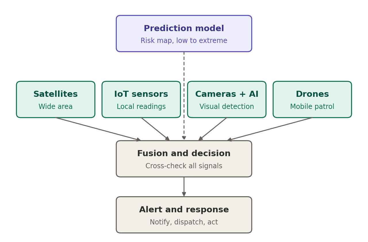
Combining tools is not a cure-all. It creates new decisions about who checks an alert, how many false alarms are acceptable, and what happens if a battery fails or a network goes offline. In remote forests, a warning system is useful only when its messages are both believable and actionable (Giannakidou et al., 2024; Khan et al., 2026).
5Conclusion
There is no single best way to monitor wildfire. Prediction helps identify where to concentrate attention; satellites offer wide coverage; ground sensors and cameras provide local evidence; and drones can investigate places that are difficult to reach. The methods become more useful when their weaknesses are recognised instead of hidden behind claims of perfect accuracy.
The 2026 haze episode in Southeast Asia shows why early warning matters beyond the area where a fire starts. Technology will not replace prevention, land management or emergency response. But finding and confirming a fire while it is still small can make those efforts more effective. For engineers, the difficult question is practical: can a system remain affordable, low-power and dependable through an entire dry season, not just during a demonstration (Khan et al., 2026)?
6Acknowledgment and AI disclosure
The author thanks Farhan Rasool for his mentorship, supervision of the manuscript, and assistance with grammatical editing. The figure was created using Claude Sonnet 5.
References
- [1]Agence France-Presse (2026). Indonesia haze spikes Singapore pollution, shuts Timor Leste schools. The Jakarta Post, 14 October 2026. https://www.thejakartapost.com/world/2026/10/14/indonesia-haze-spikes-singapore-pollution-shuts-timor-leste-schools
- [2]Bruno AG, Moore DP, Harrison JJ, Graham A, Chipperfield MP, Vigouroux C (2026). Hydrological drivers of hydrogen cyanide wildfire emissions from Indonesian peat fires during the 2015, 2019, and 2023 El Niño events. Atmospheric Chemistry and Physics, 26(17), 12925–12952. https://doi.org/10.5194/acp-26-12925-2026
- [3]Catargiu C, Cleju N, Ciocoiu IB (2024). A comparative performance evaluation of YOLO-type detectors on a new open fire and smoke dataset. Sensors, 24(17), 5597. https://doi.org/10.3390/s24175597
- [4]Coffield SR, McCabe TD, Schroeder W, Chen Y, Scholten RC, Orland E, Liu T, Wiggins E, Randerson JT, Follette-Cook M, Morton DC (2026). Leveraging additional VIIRS information to improve wildfire tracking in the western US. Remote Sensing of Environment, 334, 115156. https://doi.org/10.1016/j.rse.2025.115156
- [5]Ejaz N, Choudhury S (2025). A comprehensive survey of the machine learning pipeline for wildfire risk prediction and assessment. Ecological Informatics, 90, 103325. https://doi.org/10.1016/j.ecoinf.2025.103325
- [6]Giannakidou S, Radoglou-Grammatikis PI, Lagkas T, Argyriou V, Goudos SK, Markakis EK, Sarigiannidis PG (2024). Leveraging the power of internet of things and artificial intelligence in forest fire prevention, detection, and restoration: A comprehensive survey. Internet of Things, 26, 101171. https://doi.org/10.1016/j.iot.2024.101171
- [7]Khan AH, Bahar AN, Wahid K (2026). A review on forest fire detection techniques: Past, present, and sustainable future. Sensors, 26(5), 1609. https://doi.org/10.3390/s26051609
- [8]Makdee S, Sangkaphet P, Boonprasom C, Chaleamwong B, Chansiri N (2026). The development of a wildfire early warning system using LoRa technology. Computers, 15(2), 105. https://doi.org/10.3390/computers15020105